

PROPERTY SEARCH

Dangerous heat to subside after today: Alicante weather forecast August 18-21
The week will be cooler but very stuffy and Thursday may bring some rain and storms
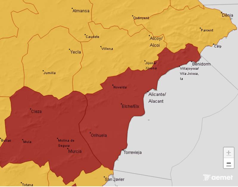
Murcia and Alicante are the only provinces in the country still on red alert today
The red alert for dangerously high temperatures continues today, after a weekend when the mercury soared far higher than had been predicted for Alicante province by state meteorological agency Aemet on Thursday.
Although the rest of the week is not predicted to be anywhere near as hot, high humidity is expected to make it feel almost as stifling.
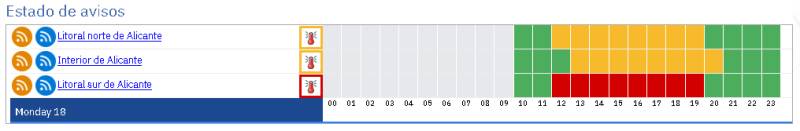
Monday, August 18
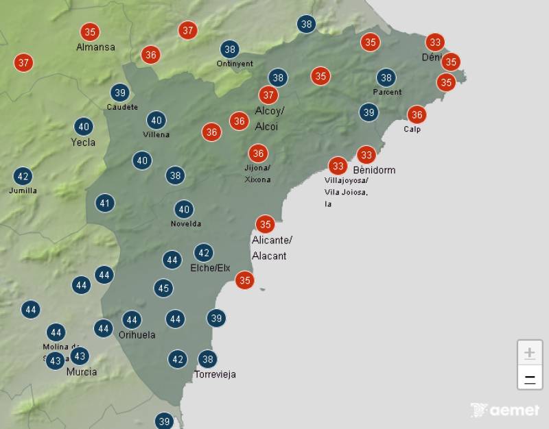
The south will be baking at 4pm
Although the table shows that the red alert is focused on the south of the province, the whole south east is liable to get up to at least 42ºC today at various times of the early afternoon.
Orihuela city may even reach 44ºC at around 4pm and even right on the coast, Torrevieja and Guardamar del Segura will not be much below 40ºC.
The high temperatures will be fuelled by hot air from the predominantly southerly breezes in the afternoon, when there may also be some cloudy intervals, and even the odd shower and storm further inland.
The heat warning is still orange, meaning significant risk, for the rest of the province, and covers from 11am to 8pm in the south and north, and 12pm to 9pm inland.
Minimum temperatures are unlikely to drop below 24ºC, or even as high as 27ºC in Alicante city.
Tuesday, August 19
The real feel will be stifling in the south by 5pm
There may not be any warnings for tomorrow, but high humidity in the afternoon will push the heat index, or real feel up to particularly uncomfortable levels in the south of Alicante province.
Temperatures of between 31ºC and 35ºC may feel more like 38-39ºC, with the humidity particularly high on the coast; reaching up to 72% at 5pm in Guardamar.
There may well be cloudy intervals and the variable light breezes will become more easterly later on.
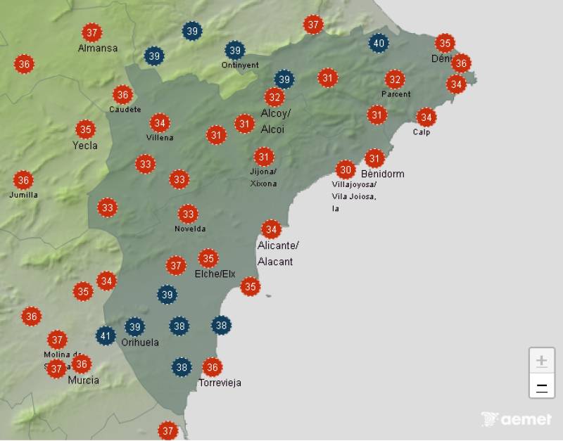
Wednesday, August 20
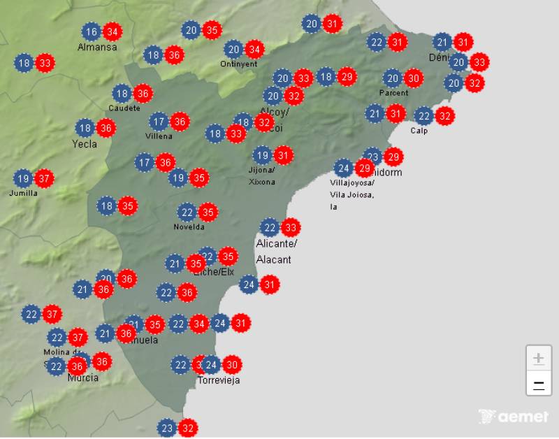
Maximum and minimum temperatures for Wednesday
Looking further ahead, the temperatures may drop slightly more on Wednesday, when there will be cloudy intervals and possibly even scattered showers and storms in the morning in the northern third of the province, particularly inland.
It is still likely to be particularly humid along the coast, not dropping below 60% in most places.
Thursday, August 21
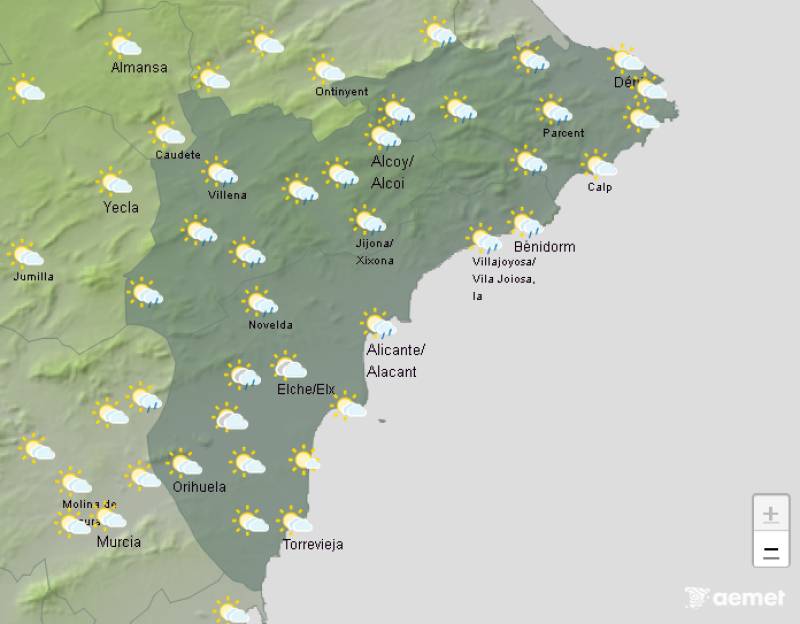
There is a strong possibility of rain forecast on Thursday
At the moment, it is looking like cloudy intervals may well bring scattered showers to many places all over the province on Thursday, occasionally accompanied by storms.
The maximum and minimum temperatures may drop slightly further and moderate north-easterly winds are predicted for the coast, with light, variable breezes around the rest of the province.
As always though, keep an eye on the forecast closer to the time as the chances of rain could decrease or bigger storms may evolve.
Find all the latest weather and climate change news here or join our Alicante Weather Watch Facebook group for regular updates
Images: Aemet


Sign up for the Spanish News Today Editors Roundup Weekly Bulletin and get an email with all the week’s news straight to your inbox
Special offer: Subscribe now for 25% off (36.95 euros for 48 Bulletins)
OR
you can sign up to our FREE weekly roundup!
Read some of our recent bulletins:
Discount Special Offer subscription:
36.95€ for 48 Editor’s Weekly News Roundup bulletins!
Please CLICK THE BUTTON to subscribe.
(List price 3 months 12 Bulletins)
Read more stories from around Spain: