article_detail
Date Published: 27/11/2023
Dry in the south and stormy in the north: Spain weather forecast Nov 27-30
After a pleasant start, the rain will become widespread across Spain towards the end of the week
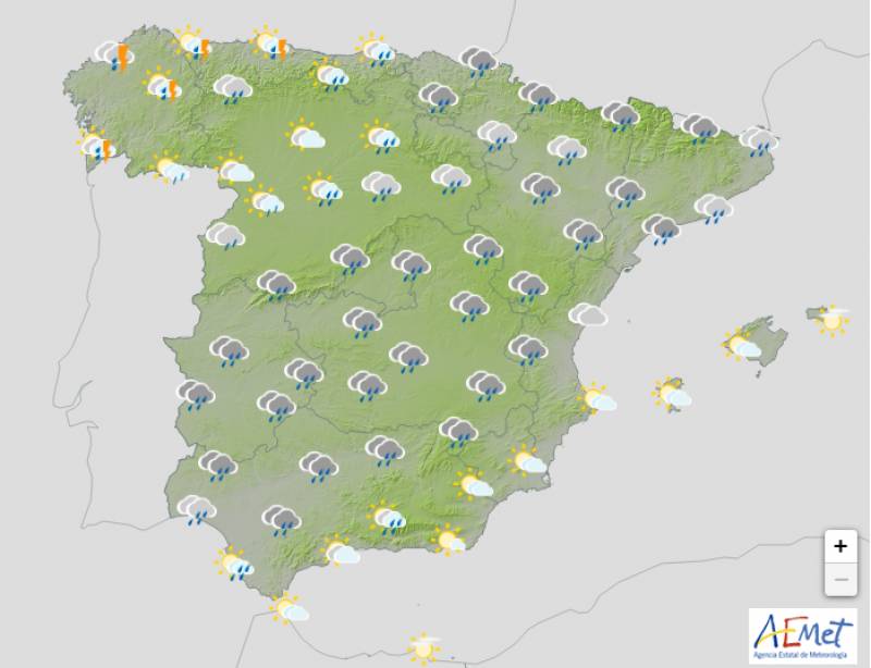
Weather outlook on Thursday November 30
Two powerful anticyclones will migrate north and point towards Europe this week, leaving Spain largely unprotected against Atlantic storms. This will create very unsettled and variable weather, with heavy clouds, strong winds and stormy episodes forecast in many areas while the southeast will remain bone dry, bright and sunny.
Much of inland and southwest Spain can expect plenty of rainy intervals later in the week also, but this shouldn’t touch the Mediterranean area or the Balearic or Canary Islands.
The week will be warm overall thanks to the arrival of the anticyclones, and the evenings will be especially balmy. In fact, the maximum temperatures will exceed 20ºC on the shores of the Mediterranean and both archipelagos, and by Wednesday the thermometers are tipped to reach 25ºC in the Gulf of Valencia, Murcia, Almería and the Canary Islands.
Monday November 27
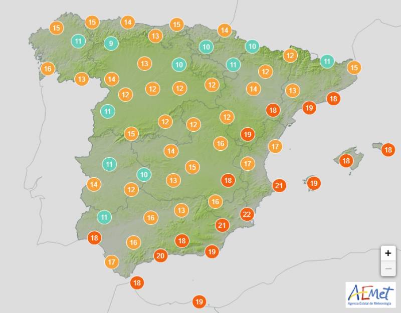
The weather on Monday will be a little changeable with cloud cover extending from west to east as the hours go by, although the Mediterranean and extreme south will be mostly clear. Weak rainfall is forecast in the north and Asturias, Cantabria, Catalonia and the Basque Country are all on yellow alert for rough seas in the afternoon and evening.
Daytime temperatures will begin to climb in the southeast and the Balearic Islands but decrease elsewhere, while the evening will also be milder than on previous days.
Tuesday November 28
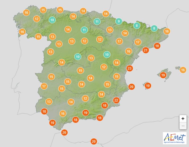
Several Atlantic fronts will enter from the northwest on Tuesday and create an abundance of overcast skies, except in Mediterranean areas where the day will be largely clear with cloudy intervals.
On the other hand, in Galicia and the rest of the Cantabrian area, rainfall will increase, growing in intensity and extent as the day progresses. It is also likely that some rain will occur, although weakly and occasionally, in the rest of the Atlantic slope, the Strait and areas of the southeast of Spain.
Night-time temperatures will rise sharply across the board but few changes are expected during the day.
The Valencian Community and Catalonia are on yellow alert for strong winds.
Wednesday November 29
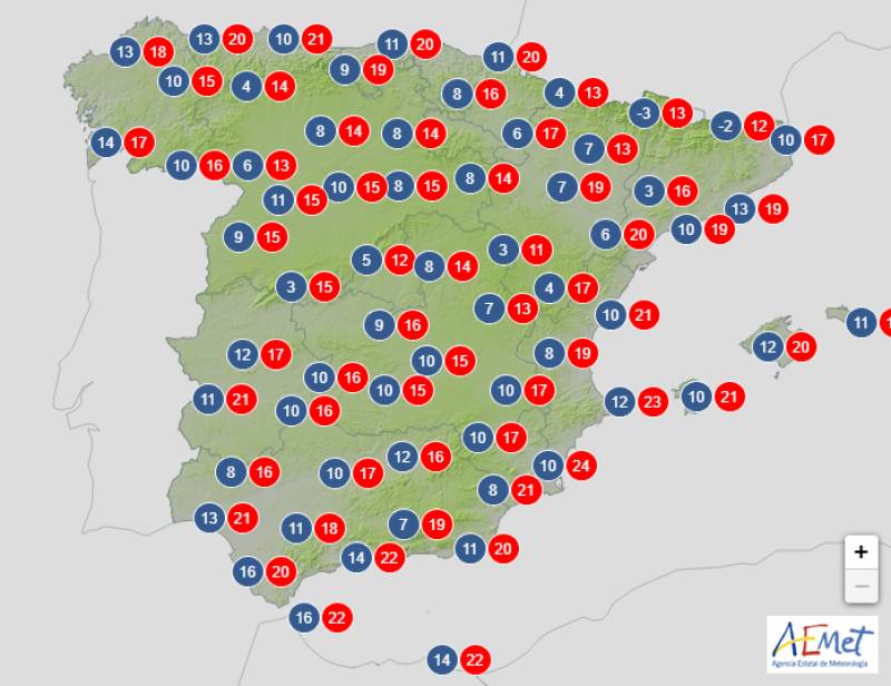
The mercury will take another big upswing in much of the country on Wednesday and most areas will see the thermometers hit the high teens of low 20s.
Low Atlantic pressures will leave cloudy skies and scattered rain in northern Spain, but far less cloudiness in expected in the Mediterranean and inland areas of the northeast.
In the extreme southeast of the country and the Balearic Islands, slightly cloudy skies will predominate without rain, while in the Canary Islands there will be intervals of clouds without ruling out some weak precipitation in the northwest of the archipelago.
Thursday November 30
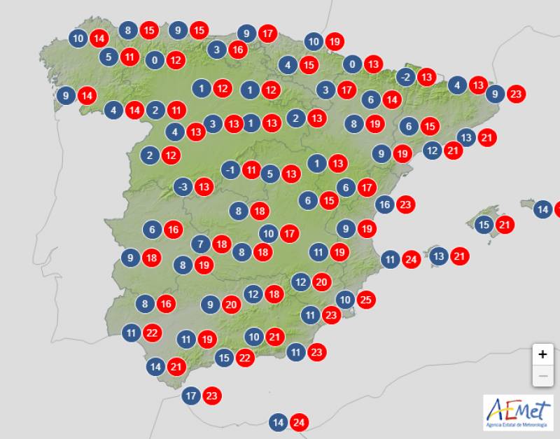
Almost widespread rainfall is expected on Thursday although as usual, this is unlikely to reach the extreme southeasterly coast. The showers will be heaviest in the north and some areas of the Atlantic slope and the day will be marked by cloudy intervals throughout.
Temperatures will remain steady or even rise slightly along the Mediterranean with few changes elsewhere.
Join our Spain Weather Watch Facebook group for regular updates
Images: Aemet
Loading
Sign up for the Spanish News Today Editors Roundup Weekly Bulletin and get an email with all the week’s news straight to your inbox
Special offer: Subscribe now for 25% off (36.95 euros for 48 Bulletins)
OR
you can sign up to our FREE weekly roundup!
Read some of our recent bulletins:
Discount Special Offer subscription:
36.95€ for 48 Editor’s Weekly News Roundup bulletins!
Please CLICK THE BUTTON to subscribe.
(List price 3 months 12 Bulletins)
Read more stories from around Spain:
Contact Spanish News Today: Editorial 966 260 896 /
Office 968 018 268


