article_detail
Date Published: 22/01/2024
January beach days just around the corner: Spain weather forecast Jan 22-28
After a stormy few days, the temperatures across Spain are expected to shoot up again this week

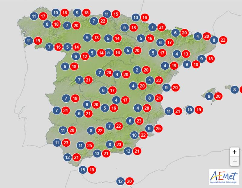
Weather outlook on Wednesday January 24
Last week was marked by driving rain, powerful gusts and freezing temperatures caused by storm Juan but that’s soon to be a distant memory. In the coming days, a powerful anticyclone will settle over Spain, bringing with it a mass of subtropical warm air that will ensure balmy temperatures between now and at least the beginning of February.
With the usual exception of the extreme north, there’s practically no rain forecast anywhere else in Spain over the next 7 days or so, and the State Meteorological Agency (Aemet) is expecting the mercury to shoot up by as much as 10ºC in large parts of the south.
On the Mediterranean coast the mercury will drop to 10-14ºC during the nights, so the evenings will continue to be chilly.
High pressures will result in a mostly clear and bright day in much of Spain on Monday January 22 although a persistent Atlantic front to the north of the country will bring light rain and overcast skies to Galicia, Asturias and a good part of Castilla y León.
Daytime temperatures will begin to slowly climb into the high teens and low 20s, weakening the frosts that have blanketed much of inland Spain in the last few days.
During the first half of the day, gusts will exceed 70 km/h on the coast of A Coruña and the western half of Asturias. As the days go by, the high pressures will strengthen, so the wind will tend to calm down.
Things will really begin to heat up on Tuesday January 23 and Aemet expects the thermometers to sail past 20ºC in much of the south, the Mediterranean coast and the Balearic and Canary Islands.
The warmest days of the week will be Wednesday January 24 and Thursday January 25, with maximums of 24 to 26ºC forecast in the Guadalquivir valley, the Andalucian Coast, the Region of Murcia and the Valencian Community.
Throughout the week fog banks may form at the sea, leaving a cooler atmosphere in coastal areas of the Mediterranean. However, these maritime fogs will tend to dissipate in the central hours of the day, giving way to warmer afternoons.
This pleasant weather is expected to last throughout Friday January 26 and Saturday 27, with mostly clear or slightly cloudy skies likely in most parts of Spain and virtually no rain on the horizon.
Daytime temperatures will begin to drop over the weekend, but the mercury will still hit 22ºC or 23ºC in the likes of Murcia and Almeria.
An anticyclonic situation should continue on Sunday January 28 and into the middle of next week, resulting in bright, sunny skies and dry, warm days. While the temperatures will continue to decline across the board, all of Spain will still be much hotter than is usual for this time of year.
Join our Spain Weather Watch Facebook group for regular updates
Image: Aemet
Loading
Sign up for the Spanish News Today Editors Roundup Weekly Bulletin and get an email with all the week’s news straight to your inbox
Special offer: Subscribe now for 25% off (36.95 euros for 48 Bulletins)
OR
you can sign up to our FREE weekly roundup!
Read some of our recent bulletins:
Discount Special Offer subscription:
36.95€ for 48 Editor’s Weekly News Roundup bulletins!
Please CLICK THE BUTTON to subscribe.
(List price 3 months 12 Bulletins)
Read more stories from around Spain:
Contact Spanish News Today: Editorial 966 260 896 /
Office 968 018 268


