


PROPERTY SEARCH

Mediterranean coast prepares for torrential storms: Spain weather forecast Aug 31-Sept 3
Widespread rain, hail and gusts are expected throughout Spain over the coming weekend
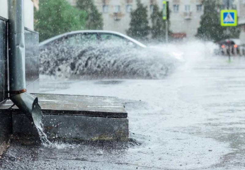
Even while the sun is still shining and the temperatures remain in the balmy 30s, the entire Mediterranean coast is preparing to batten down the hatches in anticipation of a “historic and extraordinary” DANA (Isolated Depression at High Levels) this weekend that threatens torrential storms and intense and persistent rain.
According to the State Meteorological Agency (Aemet), the northeast of Spain will be hardest hit although the path of the storm is very unpredictable and the experts warn that the whole country should be prepared for extreme weather.
Given these forecasts, many coastal municipalities in the Valencian Community, the Balearic Islands and Catalonia are already taking measures to minimise damage, including intensifying the cleaning of dry riverbeds and channels, as well as preparing the Local Police and fire departments to face the emergencies.
"We are expecting a weekend with winter weather and we are working to have everything ready so that hopefully nothing happens. We are cleaning scuppers and reviewing rain channels and the Police are notified," explained the mayor of the Valencian municipality of Oliva, Yolanda Pastor.
Could the damage of 2019 be repeated?
Meteorologists agree that the approaching DANA is going to be intense and on the Mediterranean coast they fear that the damage caused by the 2019 storm could be repeated, when a powerful cold drop flooded large areas of Alicante and Murcia and more than 4,000 people had to be evacuated.
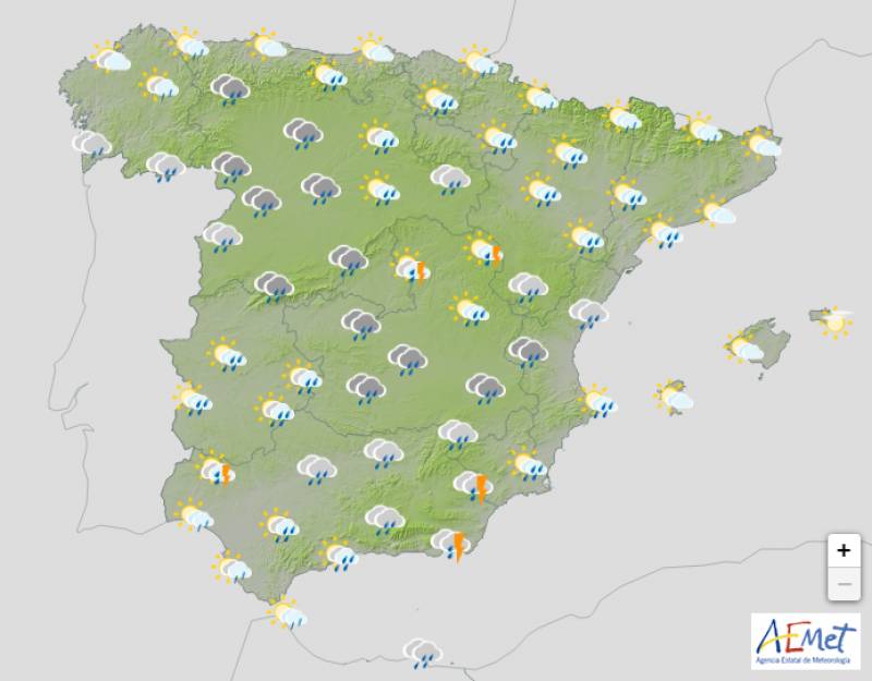
Thursday August 31
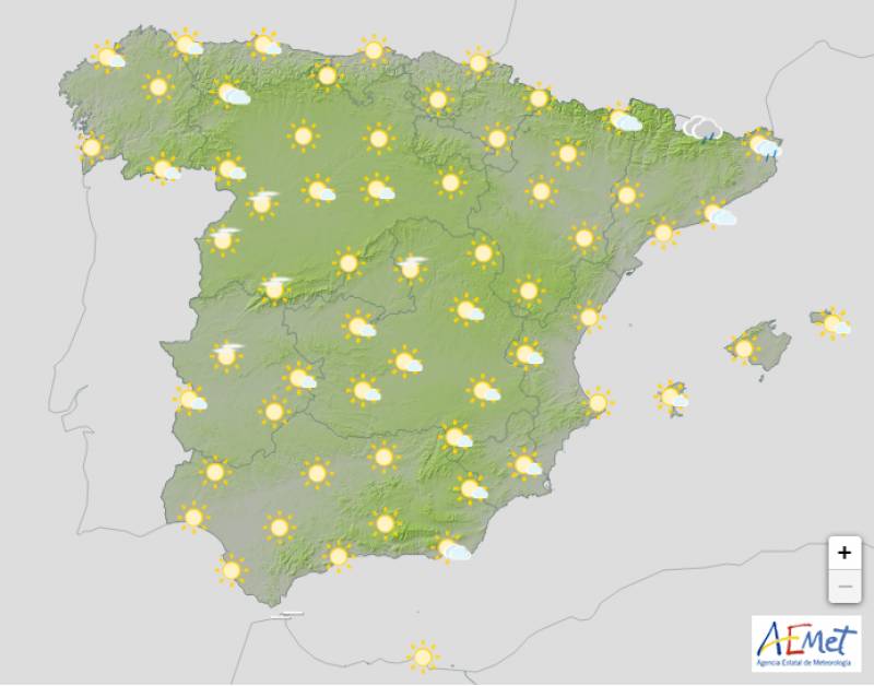
Things should remain relatively calm on the last day of August, with only Catalonia on yellow alert for some coastal storms early in the morning, although the rain could extend to the Balearic Islands. This will die off towards the afternoon to be replaced with widespread cloudy skies, but the chance of showers returns in the southeast of Spain later in the day.
Daytime temperatures are on the rise in central and northern Spain but the mercury will drop in the south of Andalucia, with few changes elsewhere.
Friday September 1
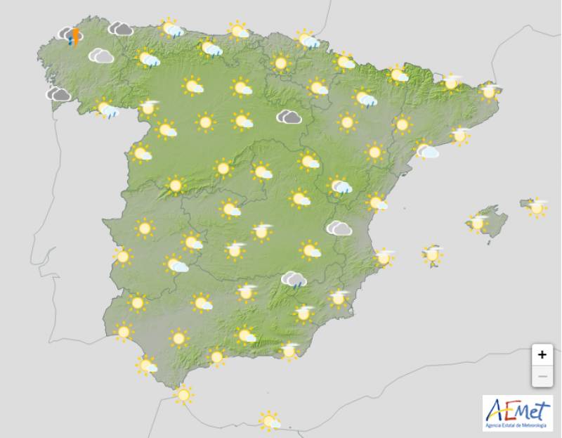
As we enter September, the anticipated Atlantic front will sweep the extreme northwest, resulting in heavy rainfall in Galicia and western Asturias. In the rest of the country, slightly cloudy skies are forecast on Friday although it will grow more overcast in the afternoon, with a good chance of stormy intervals and hail in Navarra, north of Aragon and surrounding areas.
Nighttime temperatures will hover between the high-teens and low-20s across the board but during the day the mercury will begin to fall in western and northeastern Spain.
Yellow weather alert for heavy rain and storms on Friday: Aragon, Castilla-La Mancha, Madrid, Navarra.
Saturday September 2
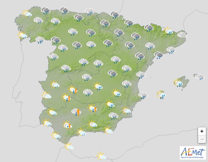
Spain will begin to feel the real effect of the DANA on Saturday with most of the country on alert for overcast skies, abundant rainfall and stormy episodes. The storms will be far more intense in the northeast and inland areas, but as the day goes on, the front will move away from the Basque Country and Navarra, pass through Aragon and hit the southern half of Catalonia and the Valencian Community.
There is still a great deal of uncertainty around how the storms will evolve, but at the moment the rainfall is expected to be less extreme in Andalucia and western Spain.
Nighttime temperatures will increase in the north and northeast but dip in central and southern Spain and the Balearic Islands. At the height of the day, thermometers will fall pretty much everywhere.
Yellow weather alert for heavy rain and storms on Saturday: Aragon, Cantabria, Castilla-La Mancha, Catalonia, Madrid, Navarra, Basque Country, Valencian Community.
Sunday September 3
No weather alerts have yet been issued for Sunday, but the day again promises to be mostly cloudy with widespread rain and storms. The worst of the weather will remain in the northeast and the Balearic Islands although the front could extend down as far as the Gulf of Cádiz. In addition, there’s the strong possibility of a calima in eastern Spain which would bring an episode of muddy rain.
Minimum temperatures decreasing in the southern half of the country and the Canary Islands, increasing in Galicia. Daytime temperatures in decline in the southeast and on the rise in Galicia and Cantabria. No big changes in the rest of Spain.
Join our Spain Weather Watch Facebook group for regular updates
Images: Meteored / Aemet


Sign up for the Spanish News Today Editors Roundup Weekly Bulletin and get an email with all the week’s news straight to your inbox
Special offer: Subscribe now for 25% off (36.95 euros for 48 Bulletins)
OR
you can sign up to our FREE weekly roundup!
Read some of our recent bulletins:
Discount Special Offer subscription:
36.95€ for 48 Editor’s Weekly News Roundup bulletins!
Please CLICK THE BUTTON to subscribe.
(List price 3 months 12 Bulletins)
Read more stories from around Spain:


Contact Spanish News Today: Editorial 966 260 896 /
Office 968 018 268