


PROPERTY SEARCH


Storms and hail unleashed this weekend: Spain weather forecast Aug 29-Sept 1
The dreaded DANA has arrived in Spain and promises a few days of widespread weather disruption
Weather alerts for thunderstorms and heavy rain on Thursday
After a fairly stable start to the week with mostly dry and sunny weather, a drastic change is coming just in time for the last weekend of the month. Many families are facing a return to work and preparing for school as September rolls around but it looks like a last jaunt to the beach might be off the table in large parts of Spain.
The first blows of the DANA struck western Spain on Wednesday August 28 as an Atlantic front rolled in, leaving plenty of rain in Galicia and Catalonia to the north.
This weather system will intensify on Thursday August 29 and result in almost widespread rain and overcast skies, although the State Meteorological Agency (Aemet) has stressed that these fronts are always very unpredictable, so the forecasts have been made with “a lot of uncertainly.”
From what meteorologists can tell at the moment, the DANA will inch in from Portugal and gradually move from north to south, producing lots of cloud cover, showers, storms and even hail. Despite this, the temperatures should remain more or less steady.
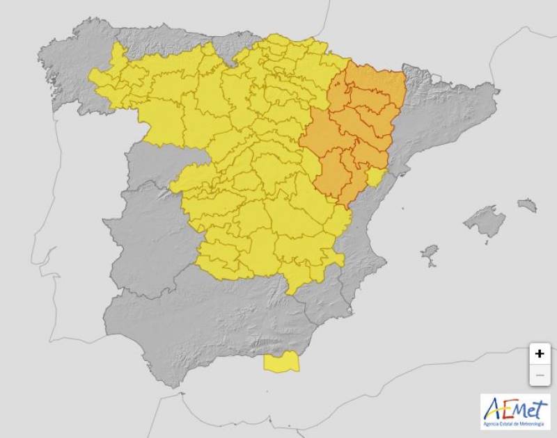
On Thursday, the worst of the storms are likely to hit western Andalucía (on alert for accumulations of more than 60 litres of rain per square metre), Castilla-La Mancha, central Madrid and Castilla y Leon. In addition, as the haze blotting the skies in southern Spain moves inland, it could result in that dreaded phenomenon of muddy rain.
The Mediterranean coast and the Balearic Islands will be spared from the worst of the rain on Thursday.
The DANA will move towards the north of the country from Friday August 30 and is expected to remain there throughout the weekend, especially impacting the provinces of Galicia, Castilla y León and Asturias.
Day-time temperatures will rise in southern Spain and Andalucía has been issued with a yellow alert for rough seas due to strong winds.
On Saturday August 31, the showers will extend somewhat further inland, persisting in the north, although all of the weather warnings have been lifted. In the rest of Spain, the DANA will start to weaken but the skies will still be very overcast across the board.
As we come to the end of the weekend, the passing fronts will create very cloudy skies in the east of the country and the Balearic Islands on Sunday September 1. Showers and thunderstorms will persist inland which could spread to the coasts in a much weaker way.
Suspended dust will make an appearance along the east coast, which could again turn to mud rain anywhere there are showers.
Join our Spain Weather Watch Facebook group for regular weather and climate change updates
Image: Aemet


Sign up for the Spanish News Today Editors Roundup Weekly Bulletin and get an email with all the week’s news straight to your inbox
Special offer: Subscribe now for 25% off (36.95 euros for 48 Bulletins)
OR
you can sign up to our FREE weekly roundup!
Read some of our recent bulletins:
25% Discount Special Offer subscription:
36.95€ for 48 Editor’s Weekly News Roundup bulletins!
Please CLICK THE BUTTON to subscribe.
(List price 3 months 12 Bulletins)
Read more stories from around Spain:


Contact Spanish News Today: Editorial 966 260 896 /
Office 968 018 268