

The village and outlying district of Zarzadilla de Totana in the municipality of Lorca
A picturesque village in the mountains on the road between Lorca and Bullas
 Zarzadilla de Totana is a small village with around 500 residents in the “Tierras Altas” area of the vast municipality of Lorca, located on the MU-503 road which crosses the high ground between Lorca to the south and Bullas, Caravaca de la Cruz and Cehegín to the north.
It is also one of the 39 “diputaciones” of Lorca, which is sub-divided in this way due to its sheer size: covering an area of 1,675 square kilometres, it is the second largest municipality in Spain.
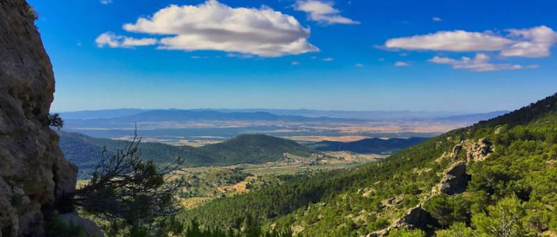
The village of Zarzadilla is at the foot of the mountains of Sierra de Pedro Ponce, one of the most mountainous areas of Lorca, and takes its name from the abundant “zarza” plants (brambles) which characterize the local vegetation. However, it is also home to plenty of vines, pines and almond trees, and grapes and almonds are a staple of the modest local economy.
The spectacular landscape of the area is perhaps best appreciated from the top of the Cabezo de la Cruz, and adventurous walkers can also make their way up to the Cerro de la Selva and the Morrón de Rivazuelo, the highest point in Lorca at an altitude of over 1,500 metres above sea level.
This is a great area for hiking and mountain biking, with a plethora of old paths which were created and used in past centuries so that locals could reach all areas of the mountains. These are now being recovered for hikers, and visitors will also be curious to see the 18th century wash-house, which is still in use, and the aqueduct which helped to provide drinking water to the city of Lorca in the same century.
The patron saint of Zarzadilla is San Miguel, whose feast day is celebrated in the local fiestas on the last Friday of September, and three country routes (two for hikers and one for mountain-bikers) have been included in Lorca’s “Caminos del Sol” catalogue:
- The Cejo Colorado hiking route (17.6 km, approximately 5 and a half hours, medium-high level of difficulty) (click for further information)
- The Malvariche MTB mountain bike route (36 km at altitudes of between 500 and 860 metres above sea level))
- The Cabezo de la Cruz walk, suitable for families with children (6.5 km, 1 hour 50) (click here for further information)
Bars and restaurants
- Bar Los Nenes, Plaza Constitución, 19, 30814 Zarzadilla de Totana, telephone 653 280720.
- Local pensionista, Rivera de San Miguel, 2, 30814
Accommodation
- Casa Marsilla, telephone 868 701382
- Casa San Miguel, telephone 659 368393
Shops
- Comestibles Loli, Calle San Isidro
- Comestibles Inés, Calle Constitución
- El horno de Agus, Rivera de San Miguel, 5
Dispensing Chemist
Botiquín Abad, Calle Constitución, 5, telephone 968 494097
Places of interest
- 18th-century wash-house
- 18th-century aqueduct
Oficina de Turismo de Lorca

The rich and extensive history of Lorca has left a legacy of archaeological sites and historic buildings around which the modern city has built its tourism industry. Amongst these are Lorca Castle, Plaza de España, the former Collegiate church of San Patricio, the municipal archaeological museum, the Casa Huerto Ruano, the Palacio de Guevara and the churches and convents of San Francisco, San Mateo, the Virgen de las Huertas, La Merced, El Carmen and many others.
Unfortunately, Lorca has been prone to natural disaster, suffering a severe flood in 1973 which killed 50 people, and a Gota Fría on September 28th 2012, as well as a series of earthquakes, the most recent of which was 5.3 on the Richter scale on 11th May 2011 and claimed 9 lives.
 Lorca also has an area of unspoilt coastline incorporating the Parque Regional de Cabo Cope - Puntas de Calnegre, which includes the beaches of Puntas de Calnegre, Cala Calnegre and various others. Although only one is accessible by road others can be reached along dirt tracks!
In terms of fiestas, Lorca is synonymous with Easter (Semana Santa), its biblical parades of International Tourist Interest status being famous throughout Spain. The week includes a series of parades in which the whites (Paso Blanco) and blues (Paso Azul) try to outdo each other with the magnificence of their embroideries and the skill and daring of their horsemen.
In the Autumn Lorca also celebrates the Fiestas of San Clemente and a Feria and there are a series of important events throughout the year in the Recinto Ferial, as well as a busy cultural and sporting programme.
The tourist office relocated for 14 years to Calle San Patricio, near the church, but has now returned to its former premises alongside the Palacio de Guevara in the Plaza Concha Sandoval, or Plaza de la Bordadora (click for map).
 Lorca also has an area of inspoilt coastline incorporating the Parque Regional de Cabo Cope - Puntas de Calnegre, in the Sierra de Almenara, which includes the beaches of Puntas de Calnegre, Baño de las Mujeres, San Pedro, El Siscal, Cala Honda, Cuartel del Ciscar, Junquera, Cala de la Gruta, Cala Leña, Los Hierros, Cala Blanca and Playa Larga, although many are accessible only along difficult tracks or by boat!
 However, in spite of its many attractions, the name of Lorca is synonymous with Easter, (Semana Santa) its biblical parades of International Tourist Interest status and famous throughout Spain. The week includes a series of processions in which the Whites (Paso Blanco) and Blues (Paso Azúl) try to outdo each other with the magnificence of their embroideries and the skill and daring of their horsemen.
Lorca also has a Parador hotel, located within the historic castle.
Opening hours for Lorca tourist office:
Every day of the year apart from 1st and 6th January and 25th December, 10.00 to 14.00 and 16.30 to 18.30 (except Sunday afternoons).
These opening times are often extended and other information points created during the Semana Santa celebrations.
For more local news, events and visiting information go to the home page of Lorca Today