Walking in the Lorca countryside, the Las Atalayas route around the village of Coy
A 14-kilometre route in Lorca which reaches 1,100 metres above sea level
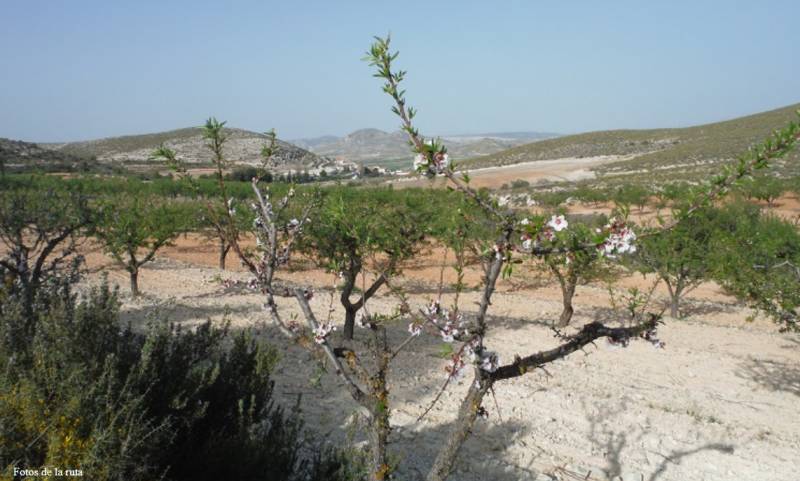 This 4-hour walking route is based in the village of Coy, one of the furthest north in the huge municipality of Lorca, about 850 metres above sea level on the southern slopes of the Sierra de la Lavia next to the source of a natural spring (although the route rises to 1,100 metres above sea level). This is an area of deep-rooted traditions including the creation of brightly coloured “jarapa” rugs and carpets and various meat products.
The walk begins in the Plaza de Casa Granda in the village, alongside the hostel of the same name, and follows Calle Noguera Bana before heading off left to a recreational area and passing through small crop fields: take care with the various crossroads along the way! Cross a tarmacked path after 2.5 km and the route goes up the Collado de los Venenos among pine and almond trees: after rounding the hill and leaving the pines behind you reach the Cortijo de las Atalaya at 7.2 km, where there is one of the most spectacular trees in the Region of Murcia. This is the “Carrasca de la Atalaya”, some 400 years old and measuring 14.35 metres in height and 5 metres around.

For more local information including news and what’s on go to the home page of Lorca Today.
Oficina de Turismo de Lorca

The rich and extensive history of Lorca has left a legacy of archaeological sites, and historic buildings, around which the modern city has built its tourism industry. Among these are Lorca Castle, the Jewish quarter of the castle and synagogue, Plaza de España, Colegiata de San Patricio, Museo de Arqueologico Municipal, Iglesia de San Francisco, Casa Huerto Ruano, Palacio de Guevara, Iglesia de San Mateo, Pósito de los Panaderos, Convento Virgen de las Huertas, Antiguo Convento de la Merced, Iglesia del Carmen and the Teatro Guerra.
 Unfortunately Lorca has also been prone to natural disaster, suffering a Gota Fría on September 28th 2012, as well as two earthquakes measuring 5.3 and 5.5 on the Richter scale on 11th May 2011, claiming 9 lives. Since this earthquake the city has been rebuilding, winning recognition for its Lorca, Open for Restoration initiative, which used the restoration of the city as a tourist attraction whilst it rebuilt its historical buildings, some of which are currently still not open.
The tourist office relocated for 14 years to Calle San Patricio, near the church, but has now returned to its former premises alongside the Palacio de Guevara in the Plaza Concha Sandoval, or Plaza de la Bordadora (click for map).
Lorca also has an area of coastline incorporating the Parque Regional de Cabo Cope - Puntas de Calnegre, in the Sierra de Almenara, which includes the beaches of Puntas de Calnegre, Baño de las Mujeres, San Pedro, El Siscal, Cala Honda, Cuartel del Ciscar, Junquera, Cala de la Gruta, Cala Leña, Los Hierros, Cala Blanca and Playa Larga, although many are accessible only along difficult tracks or by boat!

However, in spite of its many attractions, the name of Lorca is synonymous with Easter, (Semana Santa) its biblical parades of International Tourist Interest status and famous throughout Spain. The week includes a series of processions in which the Whites (Paso Blanco) and Blues (Paso Azúl) try to outdo each other with the magnificence of their embroideries and the skill and daring of their horsemen.
Lorca also has a Parador hotel, located within the historic castle.
Opening hours for Lorca tourist office:
Every day of the year apart from 1st and 6th January and 25th December, 10.00 to 14.00 and 16.30 to 18.30 (except Sunday afternoons).
These opening times are often extended and other information points created during the Semana Santa celebrations.
For more local news, events and visiting information go to the home page of Lorca Today


