article_detail
Date Published: 25/04/2024
Icy storm from Greenland descends on Spain: Weather forecast April 25-28
Spain braces for springtime snowstorms, heavy rain and more chilly temperatures

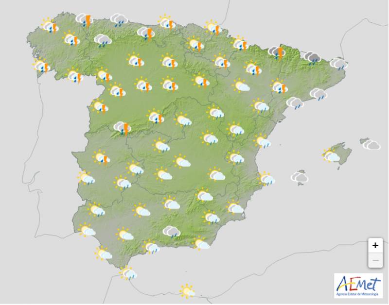
Weather outlook on Saturday April 27
After a brief taste of summer, Spain is bracing itself for an abrupt return to wintry weather. Throughout this week, an arctic polar mass has brought colder temperatures, setting the stage for another incoming front. This weekend marks the arrival of a powerful cyclone originating from Greenland, bringing rain, snow and a harsh chill typically associated with winter rather than spring.
If this event reaches a high enough intensity threshold, it will earn a name – Sancho – from the predetermined official list maintained by Southern European Meteorological Services.
The Atlantic storm will continue to gain ground on Thursday April 25, especially hitting the northern regions of Galicia, Asturias and Castilla y León with heavy rain and plummeting temperatures as the hours go by.
Cloud cover will extend during the afternoon but the south and southwest should remain relatively clear for most of the day.
Overall, the temperatures will remain relatively stable for the time being.
The instability will grow on Friday April 26 as the Greenland storm creeps closer and closer. While some clearings will open up from time to time, the day will be mostly cloudy or overcast in all of Spain and in the Balearic Islands. Showers will sweep from west to east but it’s unlikely that the south of the country will receive much rain.
Daytime temperatures will begin to fall, but the mercury should still touch the low 20s in many coastal areas.
The real change in the weather will happen on Saturday April 27 when most of Spain will feel the true impact of this wintry storm. Rainfall is likely in the entire country with the exception of the extreme southeast, where some light showers could still make an appearance. The snow levels will drop in mountainous areas and strong storms are forecast in Aragón and Catalonia in the evening.
Throughout this day there will be a general drop in temperatures, with a cold environment that will spread across large areas of the north and centre of the country, although the Mediterranean coast should remain mild.
The outlook for Sunday April 28 depends a lot on how the storm behaves but at the moment it looks as though the skies will be very cloudy or overcast across the board. The showers will continue in western Spain, spreading to Catalonia, the Valencian Community and the Balearic Islands in the afternoon.
Sunday will be a little warmer in most places, but the thermometers will continue to fall in eastern Spain and in the Canary and Balearic Islands.
Join our Spain Weather Watch Facebook for regular weather and climate change updates
Image: Aemet
Loading
Sign up for the Spanish News Today Editors Roundup Weekly Bulletin and get an email with all the week’s news straight to your inbox
Special offer: Subscribe now for 25% off (36.95 euros for 48 Bulletins)
OR
you can sign up to our FREE weekly roundup!
Read some of our recent bulletins:
Discount Special Offer subscription:
36.95€ for 48 Editor’s Weekly News Roundup bulletins!
Please CLICK THE BUTTON to subscribe.
(List price 3 months 12 Bulletins)
Read more stories from around Spain:
Contact Spanish News Today: Editorial 966 260 896 /
Office 968 018 268


