article_detail
Date Published: 15/05/2023
Spain braces for the arrival of a DANA mid-week: weather forecast May 15-18
Temperatures will continue to rise in southern Spain this week but the mercury will plummet in the north

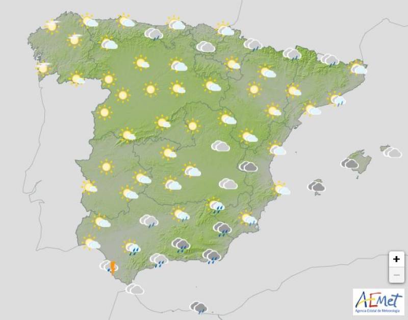
After an unseasonably warm start to spring the rain and falling temperatures that began in much of Spain over the weekend will continue well into this week, bringing abundant showers and storms to the north, inland Spain and the Balearic Islands.
On the other hand, the mercury will continue to climb in the extreme south where the weather will remain stable, bright and sunny, at least at the beginning of the week.
On Monday May 15 the northerly winds will strengthen, pulling the daytime temperatures right down in northern Spain. The State Meteorological Agency (AEMET) predicts an extreme contrast between the north and south: the mercury won’t exceed a chilly 14 or 15ºC in the likes of Oviedo, Soria and Vitoria but should soar past 32ºC in Seville and Cordoba.
It will rain heavily in the north of Galicia, the Cantabrian communities, the Pyrenees and some rain may also fall in the east of Castilla y León with stormy showers again in the afternoon in Catalonia and more dispersed in points of eastern Spain.
Aragon, the Balearic Islands, Catalonia and the Valencian Community have been issued with a yellow weather alert for gusts.
Tuesday May 16 will be much the same, although the rainfall in the north shouldn’t be quite as heavy. Cloudy intervals are forecast across the country with the northern temperatures dropping by as much as 5 or 10ºC. The mercury will also dip a little in the south, but large parts of Andalucía will still exceed 30ºC.
The Balearic Islands, Catalonia, Galicia and the Valencian Community are on yellow alert for strong winds.
Things begin to get really interesting on Wednesday May 17 when an approaching DANA will result in drastically lower temperatures and lots of rain that should hit the southwest of the country by Friday. In the Mediterranean, an easterly wind will predominate, which will bring humidity and showers, according to Aemet.
The first effects of the DANA will be felt on Wednesday morning, with a cold front resulting in showers in inland Andalucía, southern Extremadura and Castilla-La Mancha, spreading to a large part of the south later in the day. Locally strong storms are expected in Huelva and a large part of Seville and Cordoba.
Daytime temperatures will drop in the Mediterranean and the southern third of the country in general, with few changes or slight increases in the rest of Spain.
A yellow weather warning for gusts will remain in place in the Balearic Islands and Catalonia.
On Thursday May 18 the instability will spread to much of central Spain and while the progress of the DANA is still very uncertain, the meteorologists believe its approach will result in widespread cloudy skies, along with showers and occasional storms in the east and south.
The worst of the weather on Thursday will likely be centred on the Gulf of Cadiz and mountainous areas of Andalucía, Murcia and the Valencian Community.
Daytime temperatures will tend to drop, more pronounced in the eastern part of the country, although rises are expected in the southwest.
Join our Spain Weather Watch Facebook group for regular updates
Image: Aemet
Loading
Sign up for the Spanish News Today Editors Roundup Weekly Bulletin and get an email with all the week’s news straight to your inbox
Special offer: Subscribe now for 25% off (36.95 euros for 48 Bulletins)
OR
you can sign up to our FREE weekly roundup!
Read some of our recent bulletins:
Discount Special Offer subscription:
36.95€ for 48 Editor’s Weekly News Roundup bulletins!
Please CLICK THE BUTTON to subscribe.
(List price 3 months 12 Bulletins)
Read more stories from around Spain:
Contact Spanish News Today: Editorial 966 260 896 /
Office 968 018 268


